E-Scouting for Pronghorn: Finding Antelope in Open Country Before You Arrive
E-scouting western pronghorn hunting units. How to find water sources, identify buck territories, locate fence crossings, and map access routes in open desert country.

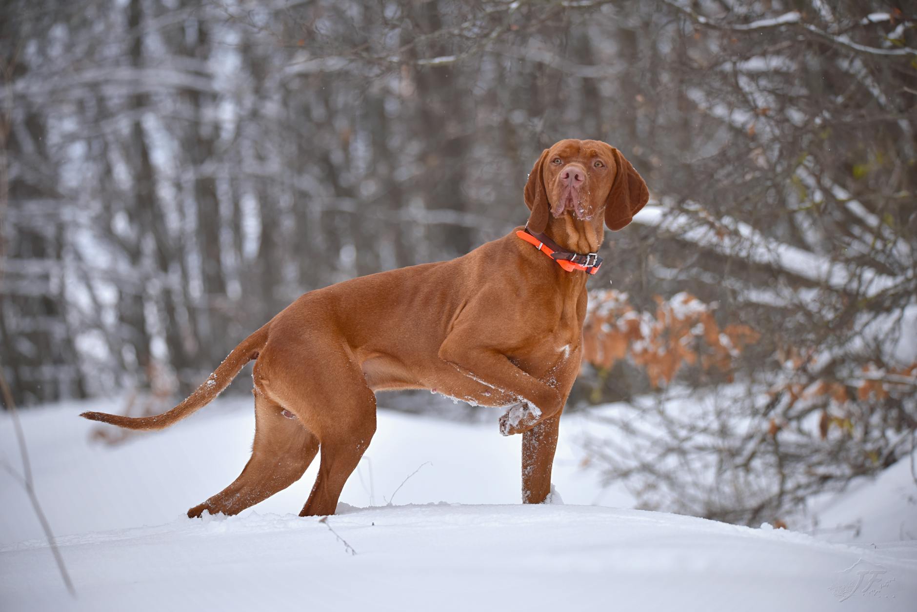
Pronghorn are the most visible big game animal in North America. They live in open country, they don’t hide in timber, and a mature buck will be standing in plain sight at 600 yards if you’re looking in the right direction. The scouting question isn’t “where are they hiding?” — it’s “where will they be at shooting light on opening morning, and how do I get within range without them detecting me from a quarter mile away?”
That’s a different problem than elk or mule deer e-scouting, and it calls for a different approach. You’re not trying to find the bedding terrain or the hidden drainage where pressure-educated animals go. You’re mapping water, travel corridors, territorial boundaries, and approach routes — and you’re doing most of that analysis before you arrive, because pronghorn country is flat enough that satellite imagery captures the relevant terrain features better than almost any other western species’ habitat.
This guide covers the complete e-scouting workflow for western pronghorn, from identifying buck territories to planning archery water-hole setups and rifle stalk routes.
What Makes Pronghorn E-Scouting Different
Pronghorn have the best far-field vision of any North American game animal. They can detect movement at 500-800 yards reliably. They see in nearly 320-degree arcs. A mature buck that spots your approach at 600 yards doesn’t run — he walks away casually at 40 miles per hour and is out of the unit before you’ve closed half the distance.
The result is that approach is everything. Before you ever set foot in a pronghorn unit, you need to know the terrain well enough to identify every wash, berm, ridge, and terrain break that will let you stay below their sight horizon. You need to know where the fences are and where the natural crossing points are. You need to know which water sources they’re using so you can intercept them on their own schedule instead of chasing them across open flats.
All of that is mappable from your desk. Pronghorn country is flat enough and open enough that satellite imagery shows you exactly what the terrain looks like at ground level. What you see in Google Earth is what you’ll see in person — mostly. That makes pre-season digital work exceptionally valuable for antelope hunting.
Step 1 — Map Water
Pronghorn in late-season conditions need water more urgently than mule deer. During July and August archery seasons and early September rifle seasons, temperatures regularly exceed 90°F in prime pronghorn habitat — Wyoming basins, Nevada flats, Arizona and New Mexico high desert. Every developed spring, livestock tank, and seasonal pond in the unit will have antelope traffic at predictable times.
Start by opening your unit in OnX Hunt or Google Earth and locating every water source. Perennial springs and developed livestock tanks show up clearly — small circular reflections or unusually green vegetation patches on otherwise brown flats. Seasonal ponds are harder; compare current imagery to imagery from a wet spring year to see where water collects. Mark each source as a waypoint.
Then rank them. Water sources within a mile of a two-track road will be glassed constantly by other hunters and may have ground blinds set up from the first week of the season. Water sources that require a two-mile walk across open flats — or better, water at the end of a long approach that uses a drainage to stay hidden — will see far less competition. A remote spring with only one or two truck tracks approaching it on satellite imagery is worth twice the hiking.
Harvest Data Tells You Which Zones Are Most Productive
ProHunt’s harvest data in the Game Activity Predictor shows where hunters have reported successful pronghorn kills by unit area. Overlay this with your water source map. Kills clustering near specific water or terrain sections tell you where the most animals have historically been — which helps you prioritize which water sources get camera time and which glassing positions cover the most productive ground.
Step 2 — Find the Flats and Benches
Pronghorn avoid terrain that restricts their visibility or their movement. Creek bottoms with tall willows, hillsides covered in thick sage, broken badlands terrain — these are not pronghorn country even when they’re inside a designated pronghorn unit. The animals are on the open flats, gentle grassy benches, and wide basin floors where they can see and run freely.
In Google Earth, zoom out to see the whole unit and identify the sections that match: light brown or tan open country, wide flat basins, gentle sage-covered benches. These are the zones you focus on. The brushy creek drainages and timbered ridges are largely irrelevant for pronghorn.
Look for mixed terrain — open flats adjacent to slightly broken ground, benches above basin floors, mesa edges that overlook wide sagebrush country. These transition areas are where bucks often set up territorial positions — they can survey large areas while having slightly elevated ground to stand on. A buck will often be visible from a long distance standing on a small rise at the edge of a bench, watching his territory.
Pay attention to vegetation density. Heavy sage, tall rabbitbrush, or dense grass that’s knee-high in wet years can obscure a pronghorn’s approach detection. During a wet year, bucks sometimes shift to shorter-vegetation areas for exactly this reason — they want to see threats coming. If it’s been a wet summer, look for areas with shorter-cropped vegetation or recent grazing pressure.
Step 3 — Identify Fence Crossing Points
This is the piece of pronghorn e-scouting that most hunters skip, and it’s one of the highest-value activities you can do from your desk.
Pronghorn don’t jump fences. They’re physically capable of clearing a four-strand barbed wire fence, but they avoid it — instead, they crawl under or through the bottom wire at specific low points. Every fence in a pronghorn unit creates a navigation channel that routes animals toward a handful of preferred crossing locations. Over time, those crossings develop visible trails on both sides. From satellite imagery, you can often spot them as slight depressions or worn areas along fence lines.
Identify all major fence lines in your unit in OnX. Look for sections where the bottom wire is visibly lower, where vegetation is worn on either side of the fence, or where terrain creates a natural low point. Mark these as potential crossing waypoints. During the season, bucks moving between grazing areas and water will funnel through these crossings consistently.
Fence crossings are the highest-percentage ambush locations for rifle pronghorn — especially in large basins where you can’t predict exactly where the animals will be at a given moment. If you know the three crossings that connect the morning feeding area to the afternoon bedding area, you have defined positions to work from rather than playing the guessing game on open flats.
Public/Private Checkerboards Are Worse in Antelope Country
Pronghorn units often contain significant private land, and the checkerboarding pattern in ranch country can make legal navigation genuinely complex. A public section surrounded on three sides by private land may have no legal vehicle access. Verify every approach route in OnX or ProHunt’s Land Access Mapper before committing to it. In some units, the best public ground is only accessible by walking across a section of private land — which means it’s not legally accessible unless you get written permission. Do this homework from your desk, not at 5 AM the morning of your hunt.
Step 4 — Plan the Approach
Pronghorn hunting fails at the approach more often than at any other stage. You can find a shooter buck at 800 yards at first light, but if you stand up and walk directly toward him, he’ll be gone before you’ve taken 20 steps. Every approach needs terrain cover.
In flat country, the only terrain cover is vertical relief: washes, dry creek channels, road berms, slight ridgelines, vegetation lines. In Google Earth, map every piece of terrain that could hide your approach to within rifle range (200-400 yards) of the areas you’ll be hunting. Trace the approach routes from potential glassing positions down to target areas. Identify which approaches require crossing open ground and how far you’d be exposed.
For each target water source or fence crossing, identify at least one approach that keeps you hidden until you’re within shooting distance. In some terrain that means a half-mile crawl through a shallow wash. In others, it means a wide arc that puts a ridge between you and the target until the last 400 yards.
Approach planning is even more important for archery pronghorn. You need to get within 30-60 yards of an animal whose primary defense is detecting threats at 600 yards. Without terrain to hide in, that’s only possible at a water hole where the animal comes to you, or using a decoy and calling setup at a fence crossing where the buck is already committed to a specific location.
Step 5 — Mark Glassing Positions
Pronghorn hunting works differently from mule deer hunting in one important way: you often glass until you find a specific animal worth pursuing, then build the stalk plan on the spot. With mule deer, you’re trying to find a buck in a specific terrain feature you identified in advance. With pronghorn, the animals may be anywhere in a large open basin — your job is to cover that basin visually until you find the right buck.
Your glassing position needs to cover as much of the unit’s prime habitat as possible simultaneously. Look for slight high points — even a 40-foot rise in otherwise flat terrain gives you a significant sightline advantage — that overlook multiple flats, bench sections, and known water sources. In some pronghorn units, a truck parked on a two-track with a good spotting scope covers more ground than any on-foot position.
Mark three or four glassing positions in your primary hunting area, noting approximately how many acres each one covers. Prioritize positions that give you views of the transition areas where bucks set up territorial positions — slight rises at the edges of flats, bench edges overlooking lower ground.
Your Truck Is the Best Blind in Open Country
In flat pronghorn country, glassing from inside your truck or from behind it is often more effective than glassing on foot. Pronghorn tolerate vehicles better than they tolerate humans on foot — they’ve evolved alongside bison-sized grazing animals and aren’t particularly alarmed by a slow-moving truck. Stop 600-800 yards from a group, glass from inside or from a window mount, and evaluate before you commit to an approach. A spotting scope on a window mount or beanbag is the setup for this — it’s stable, quiet, and lets you glass without standing on open terrain where the animals can see your outline.
Archery vs. Rifle: Scout for Different Things
The e-scouting priorities shift significantly between archery and rifle pronghorn hunting.
Archery pronghorn is a close-range game — 30-60 yards maximum for most shooters. You need a way to get the animal to come to you, or to intercept it at a location it will visit regardless of your presence. That means two things: water hole setups and decoy/fence-crossing setups. For water hole hunting, your e-scouting is about finding remote water with good blind placement opportunities — a low bank on the downwind side, natural terrain features that break up a ground blind’s outline, approach routes that don’t cross upwind of the water. For fence-crossing setups, you’re finding crossings in heavy-traffic corridors where a decoy and a call will pull a territorial buck in.
Rifle pronghorn is a glassing-and-stalk game. Your e-scouting focuses on glassing positions with maximum visibility, approach routes with terrain cover, and identifying the fence crossings and travel corridors where you can intercept moving animals. Shot distance will typically be 200-400 yards, so you need to map the areas that allow a 300-yard approach without full exposure — which in many basins means finding a route entirely underground in a wash system.
The water mapping is equally valuable for both. In either case, knowing every reliable water source in the unit gives you the ability to intercept animals on a predictable schedule rather than chasing them reactively across open ground.
Building Your Game Plan Before You Arrive
A complete pronghorn e-scouting session should leave you with a specific, layered map that answers these questions before you step out of the truck:
Where are the five best water sources in the unit, ranked by remoteness and reliability? Where are the fence crossings that connect morning feeding areas to afternoon water? Which three or four glassing positions cover the most prime habitat simultaneously? What’s the best approach route to within rifle range of each water source and each major fence crossing?
If you can answer all four of those questions before you arrive, you’re not hunting blind. You’re executing a plan. Use ProHunt’s Land Access Mapper and Draw Odds Engine to layer in public land boundaries and unit-level draw difficulty — the harder the draw, the more pre-season work the tag deserves.
Pronghorn country looks featureless from a car window. It isn’t. The washes, the fence lines, the slight elevation changes, the reliable versus seasonal water — these are the features that determine where a specific buck will be at shooting light on a given morning. Map them from your desk, verify them with a first-morning glass, and you’ll spend your tag days hunting rather than searching.
Next Step
Check Draw Odds for Your State
Tag-level draw odds across 9 western states — filter by species, unit, weapon, and points. Free to use.
Get the Insider Edge
Join hunters getting exclusive draw odds data, gear deals, and weekly hunt planning tips.
Related Articles

Arizona Elk Calling: September Archery
September archery elk in Arizona means calling. Here's the practical guide to bugles, cow calls, and the timing that produces bulls.
Arizona Hound Hunting Regulations Guide
Arizona hound hunting for bear and lion requires specific permits and tags. Here's the complete regulatory guide for 2026.

Arizona Shed Hunting: Rules & Season Guide
Arizona has specific rules on shed antler collecting. Here's the complete guide to the season, the ethics, and the most productive areas.
No comments yet. Be the first to share your experience!